


December 2, 2013 by Joseph Skulan
(Note: Recently a correspondent in Spain asked me to explain GTac’s plans to mine iron in the Penokee hills of northern Wisconsin, and the issues surrounding these plans. Believing that my reply to his request could serve as a useful introduction to the Penokee mine issue for people unfamiliar with the area, I have reproduced it here).

Map of the Bad River Watershed where all the wastewater from the mine would flow.
Gogebic Taconite (GTac), the company run by Bill Williams and owned by coal mining magnate Chris Cline, plans to build a massive open pit iron mine in northern Wisconsin, about 30 km south of Lake Superior, which at 82,000 km2 really is a freshwater sea. In its initial phase the mine would be about 1.5 km wide, 300 m deep and 9 km long. The mine eventually may be as much as 45 km long.
Geological setting: The mine targets the Ironwood formation, a typical Proterozoic banded iron formation consisting mainly of iron oxides (magnetite and hematite) interbedded with chert, with smaller amounts of other minerals, including iron sulfides and several asbestos minerals. The iron content of the Ironwood formation is low, generously 20-25%, only part of which will be recovered by the magnetic separation process Williams says the mine will employ. The existence of this deposit has been known for over 100 years. The low quality of the ore is the reason why it has never been mined on a large scale, except in places where metamorphic heating created pockets of higher grade ore. Open pit mining of the Ironwood has not previously been attempted.
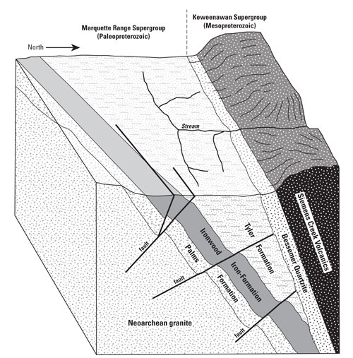
Drawing of the Ironwood Formation courtesy of http://www.wisconsinacademy.org.
The Ironwood formation is 150-200 m thick. Below it is a quartzite layer (the Palms Quartzite formation) and above it a black slate (the Tyler Slate formation). All of these beds dip 60-80˚ to the north. As a result of this dipping, the Ironwood formation is exposed on the surface as a 200-400 m wide band, bounded on the north by the Tyler Slate and on the south by the Palms Quartzite, with the Ironwood and Palms, which are more resistant to erosion than the Tyler, forming a 250-300 m high ridge. This ridge extends 120 km along the south shore of Lake Superior, in the US states of Wisconsin and Michigan. In Michigan the ridge is call the Gogebic Mountains. In Wisconsin the same ridge is called the Penokee Hills or Penokee Mountains. The steep dip of the the Ironwood means that an open pit mine of this bed rock requires a narrow and deep excavation.
Ecological setting: The Penokees are the dominant topographic feature of the south shore of Lake Superior in Wisconsin. These hills are heavily forested, contain numerous wetlands and are home to several rare and endangered organisms. The climate is cool and moist, with an average annual temperature of about 7˚C and annual rainfall of 90-100 cm. The hills are crossed by many streams that flow north into Lake Superior. Many Lake Superior fishes, including lake sturgeon, spawn in these streams. The streams also feed wetlands on the Lake Superior shore, including the Kakagon Slough, one of the largest freshwater wetlands on earth and a Ramsar Wetland of International Importance. The Kakagon Slough provides critical habitat for many birds, fishes and other animals, and contain the largest remaining stand of wild rice in America.

Tribal flags flying at the Penokee Hills Education Summit September 20, 2013.
Cultural setting: The proposed mine is in the territory of the Ojibwe (Chippewa) Nation, and just a few miles from the reservation of the Bad River band of Lake Superior Ojibwe. Obviously, the Ojibwe oppose the mine and are doing all they can to stop it. The mine threatens the Kakagon Slough and with it the wild rice that is sacred to the Ojibwe, and which they rely upon for survival, along with fish and other natural resources that also are threatened by the mine. The mine would be so destructive to the Ojibwe homeland that its effects have been described as genocidal. It appears that part of the strategy of GTac and its backers has been to win support in northern Wisconsin by inciting anti-Indian racism there. This strategy largely has failed. The people of northern Wisconsin, both Indian and non-Indian, overwhelmingly oppose the mine.
Under treaties between the United States and the Ojibwe Nation, the Ojibwe retain hunting, fishing and harvesting rights over about 35,000 km2 in northern Wisconsin, including the entire Penokee range. Under these treaties the Ojibwe also share, with the State of Wisconsin, regulatory power over the natural resources of their territory. The mine could not be built over Ojibwe objections without violating treaties and international law. However, neither the state of Wisconsin nor GTac have indicated any serious intent to obey the treaties. The national government could stop the mine, but it is not certain that it will, as mining companies have a great deal of political power In the USA.
The GTac mine threatens the environment in four ways.
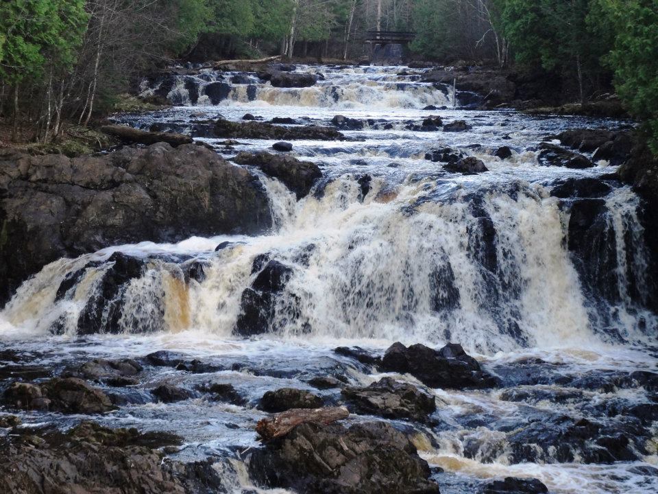
Tyler Forks River in the Penokee Hills.
1. Physical destruction of the Penokee Hills. The initial phase of mining will flatten about 9 km of hills and destroy about 65 km2 of mixed forest and wetlands. Ultimately 45 km of hills could and 200-300 km2 of forest and wetlands could be destroyed. Apart from the total destruction of the environment within the mine itself, the mine would severely damage the rivers running through it and possibly cause massive erosion and sedimentation that could kill fish spawning beds and bury the Kakagon Slough. Airborne dust could travel far from the mine site.
2. Acid mine drainage. The mine would generate enormous amounts— million of m3—of pyrite-bearing waste rock from the Tyler Shale and from pyrite-rich layers in the Ironwood formation. Bill Williams has proposed “dry-stacking” this waste on a wetland just to the south of the mine. Given the climate and hydrological conditions, along with the immense volume of waste rock, preventing the oxidation of pyrite in this rock and the generation of H2SO4 will be very difficult, and probably impossible if the mine is operated on the cheap, which it almost certainly will be. H2SO4 is especially problematic in the area because there are no large natural sources of sulfate, and the organisms that live there are not adapted to it. Wild rice is particularly vulnerable to sulfate pollution because in wetland sediments sulfate is reduce to hydrogen sulfide (H2S), which is highly toxic to wild rice. Wild rice cannot survive in water with sulfate concentrations higher than about 10 ppm, which easily could be exceeded by acidic runoff from the iron mine. Sulfate from iron mining in the neighboring state of Minnesota already has destroyed most of the wild rice beds there. For reasons given above, destruction of the wild rice beds of the Kakagon Slough would be devastating to the Ojibwe.
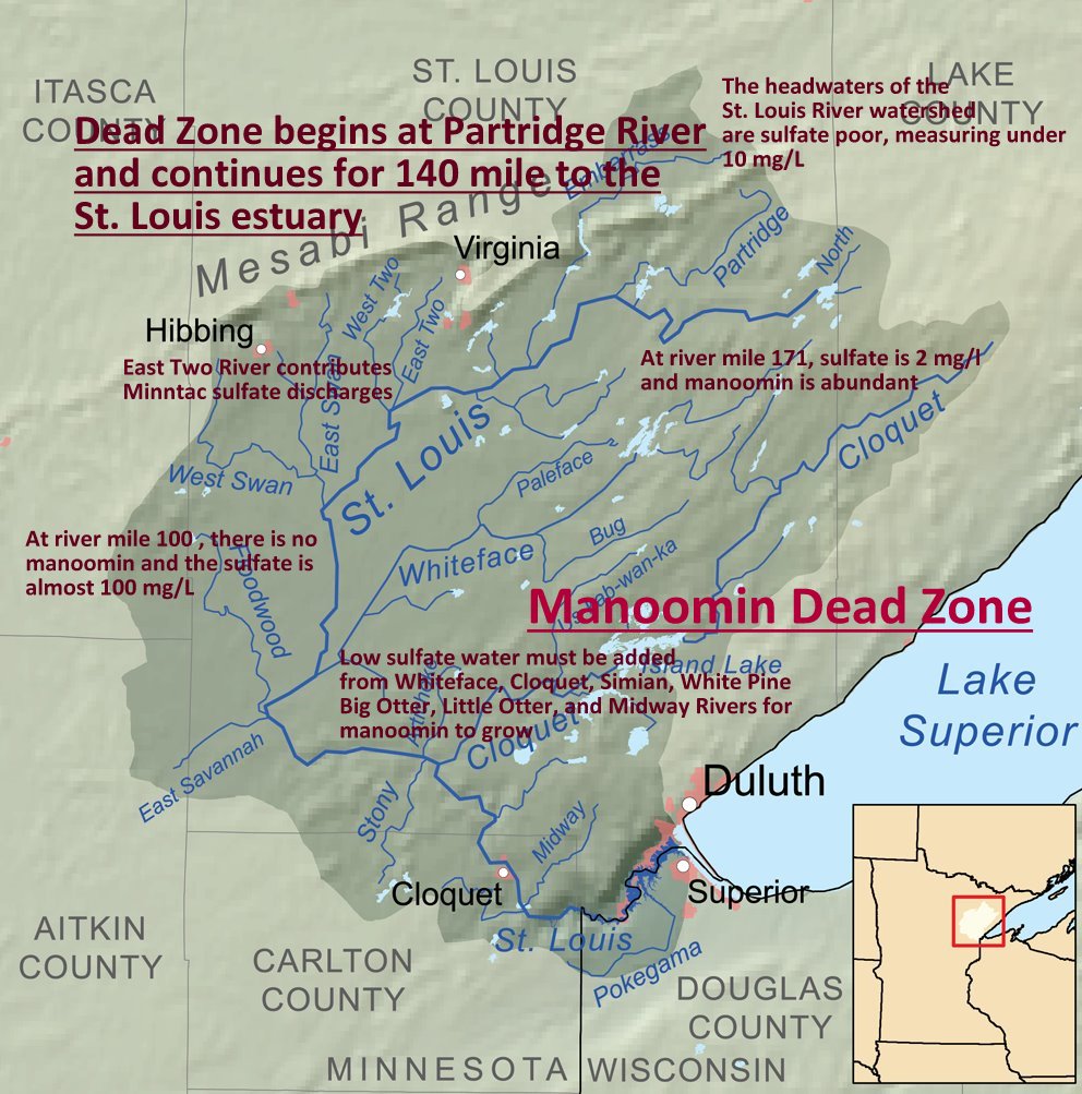
Wild rice (manoomin) dead zone on the St. Louis river from sulfates and heavy metals resulting from iron mining upriver.
3. Environmental toxins. Acid mine drainage could mobilize toxic chemicals contained in the waste rock, and deliver these toxins to surface and underground water. The toxins of most concern are arsenic, selenium and mercury. In addition, parts of the Ironwood Formation are rich in asbestiform grunerite, one of the most dangerous asbestos minerals and a primary cause of mesothelioma. Asbestos dust would pose a grave health risk for workers in the mine and possibly for surrounding communities. Silica in the form of chert is a major constituent of the Ironwood formation, and is another hazard posed by dust generated from the mine. As the mine will rely heavily on explosives, it is likely to generate a large amount of fine to ultra-fine dust that could pose health risks to people throughout the region.
4. Hydrological concerns. The Penokee ridge is hydrologically important. The elevation of the ridge provides the gravitational pressure that supplies wells with water in the lower areas around it. Destruction of the ridge will cause many wells to go dry. The pumping of massive volumes of water from the bottom of a deep mine will lower water tables, which in the area are much shallower than the mine. In addition, toxins generated by the mine easily could contaminate the local aquifer.
Bill Williams and the two other people who speak for GTac, mining engineer Tim Myers and lobbyist Bob Seitz (I don’t know if there is a Spanish term for “lobbyist”– it means, more or less, someone who makes a living by bribing government officials) have steadfastly refused to answer any questions about how they plan to prevent environmental damage. At first they denied the presence of pyrite in the rocks, and they still deny the presence of asbestos, despite abundant documentation by multiple laboratories, including the official Wisconsin laboratories. When the presence of asbestos was announced by independent scientists a few months ago, GTac and its apologists in the legislature responded by attacking the scientists and hinting that they planted asbestos on the site. GTac then had a law enacted that forbids public access to the areas where asbestos was found.
Bill Williams frequently cites the Cobre las Cruces copper mine in Spain as an example of an environmentally safe mine, and a reason why he should be trusted not to cause environmental damage in Wisconsin. This is ironic because, as you know, Williams is likely to face trial for multiple criminal environmental violations at Cobre las Cruces during his tenure there.
Until 2011 Wisconsin had strong environmental regulations under which the GTac mine could not have been built. The political situation is complicated and probably of little interest to you, but in 2011 all branches of the Wisconsin government (the governorship, the legislature and the court system) were taken over by right-wing Christian extremists backed by powerful industrial interests. Under the new government environmental regulations have been repealed and state agencies have been purged of independent scientists. GTac paid the state legislature to pass a law exempting iron mining from most environmental and mining regulation. It is under this law that the GTac project is moving forward.
GTac engineer Tim Myers, lobbyist Bob Seitz and CEO Bill Williams in front of the Iron County Board.
Currently, GTac is working with the Wisconsin Department of Natural Resources (DNR) to get approval for its plans to conduct “bulk sampling” operations on the proposed mine site. Bulk sampling means removing several thousand m3 of ore from several different sites. According to Bill Williams, these sample will be used to determine how the ore produce by the mine will be processed, and what equipment will be required to process it. It is anticipated that the bulk sampling plan will be approved over the next few months and that bulk sampling operations will be conducted this winter, while the ground is frozen and it is easy to move heavy equipment.
After the bulk sampling is completed, GTac will apply for a mining permit. This application should include detailed technical discussions of how the mine will be operated, including how environmental problems will be addressed (whether such detailed information actually will be contained in the permit application is another question). This permit application will go to the DNR for approval. There are still some competent staff at the DNR who could, in theory, deny the permit. But the practical reality is that if this happens Cathy Stepp, the Director of the DNR, will almost certainly override the decision of her staff. Stepp, an anti-environmental extremist and ally of the equally extreme Governor, has left little doubt that her goal is to approve the construction of the mine.

Sign outside of a public hearing on GTac’s bulk sampling plan August 15, 2013.
A lingering question is whether GTac actually plans to build a mine at all, or if this whole project might be a scheme either to destroy Wisconsin’s once strong environmental regulations or to defraud investors. GTac appears to have a staff of no more than 5 people, only three of whom have any scientific background. Certainly GTac currently does not have enough staff to complete the application for a mining permit, much less actually open a mine. However, given the potential disaster that a mine would be, we must assume that GTac really plans to build it and act accordingly.


Leave a comment