


November 17, 2021
Barbara With
According to a story in the Star Tribune, Minnesota Pollution Control Agency (MPCA) regulators are requesting that “a wide swath” of groups begin monitoring the state for PFAS, dangerous chemicals used across many industries that pose major threats to the environment and the health of humans and animals.
This comes after 305 more Minnesota water bodies were recently added to the impaired water list, bringing the total to over 3,000. “We looked at water across the state and found low levels of PFAS in just about all of them,” said Miranda Nichols, coordinator of the impaired water list. Dubbed “forever chemicals” because they don’t break down in the environment, PFAS are used in everything from mascara to paint to food processing equipment. More than 600 military sites across the U.S. are contaminated, the primary source coming from the use of firefighting foam made with PFAS, also known as aqueous film-forming foam, or AFFF.
The irony of MPCA’s request is that it comes 15 years after they settled a law suit brought by whistleblower Dr. Fardin Oliaei, former Senior Research Scientist and Coordinator of the Emerging Contaminants Program at MPCA. Oliaei discovered the dangers of PFCs (part of the PFAS family of substances) during her tenure at MPCA. The agency, however, responded by forbidding her from speaking about her findings or answering questions submitted to the MPCA by legisators, and cutting off her funding for investigation into chemical contaminants.
Lead attorney on the case, Rockford Chrastil, stated, “Government scientists are protected on the job by the First Amendment precisely because they work for the public. Forcing public science through the screen of politics does a dangerous disservice to the people whose drinking water and health may be at risk.” The suit was settled out of court in 2006 for $350,000.
The federal lawsuit named Sheryl Corrigan, then Commissioner of the MPCA, and her top deputies as defendants. In her resignation letter, Oliaei stated, “Since Ms. Corrigan left 3M to become MPCA Commissioner … I believe that MPCA top management has intentionally minimized the environmental monitoring of PFCs in Minnesota, even though my research has shown that PFC levels in the environment near some of the 3M facilities are among the highest concentrations reported anywhere in the world.”
Corrigan was a former employee at 3M, a major manufacturer of the chemicals in questions. She was appointed to head the MPCA by then-Govenor Tim Pawlenty in 2002. In an interview on Minnesota Public Radio in 2005, Corrigan was quoted as saying she was “not sure if research scientists belong at the MPCA,” and that until there is “the right science to move forward on,” the agency would not monitor the toxins in the state’s water supply.
Corrigan had a history of protecting the corporations that produce PFAS. A public health assessment released in 2008 by the US Department of Health and Human Services Agency for Toxic Substances and Disease Registry reported that between 1956 and 1974, PFC wastes were disposed of by 3M in two land disposal sites, in Oakdale and Lake Elmo, Minnesota. This resulted in the contamination of groundwater and nearby drinking water wells, and PFCs were detected in public and private wells across a wide area of Oakdale and Lake Elmo. Yet, in a 1998 statement to Cottage Grove residents, Corrigan stated that the landfill water flowing into the Mississippi was clean.
In 2017, Minnesota sued 3M for contamination to Twin Cities metro water that caused $5 billion worth of health and environmental damages. “3M, in pursuit of profit, deliberately disregarded the substantial risk of injury to the people and environment of Minnesota from its continued manufacture of PFCs and its improper disposal,” the state said. In response, 3M lead attorney William Brewer II said, “3M believes these chemicals present no harm at the levels they are observed in Minnesota.” The state settled for $850 million.
Today’s request from the MPCA for voluntary participation by several hundred businesses and municipalities seems too little too late. Science for the People has been conducting analyses of water and drilling fluid chemistry from ‘frac outs’ during Enbridge Line 3 construction and have asked the Army Corp of Engineers to do a complete investigation into the damages. Perhaps the MPCA can include these in their request for others to do their job for them.

Compiled Catalogue of Line 3 Failures and Violations
Updated: October 5, 2021.
Background
Water Protectors and concerned members of the public, together with scientists & technical experts, have compiled a list of known problems related to Line 3 construction and oversight, as of October 4, 2021. Listed problems fall under the categories of:
- failure by state and federal agencies to abide by treaty law;
- failure by state agencies to engage in meaningful tribal consultation;
- inspection and reporting failures by Enbridge, “independent” environmental monitors (paid by Enbridge) and agencies;
- failure by state agencies to consider or abide by the state of the science regarding water resource protection;
- false statements and obfuscation by state agencies.
These problems and failures are listed below, together with information about the attachment where you can read about them in more detail. These failures also intersect with four different types of environmental degradation documented during Enbridge construction and agency oversight of Line 3 in 2020-2021:
- The approval by MNDNR of Enbridge’s request for 5 billion gallons of water appropriations during an historic drought, a 10x increase over the original permitted amount;
- At least 28 known spills of drilling fluid chemicals into sensitive ecosystems along the pipeline route;
- An illegal breach of a sensitive artesian aquifer on January 21, 2021;
- An undisclosed number of additional violations along the route related to sedimentation of sensitive wetlands and water bodies.
Specific Line 3 problems and failures are described below.
Breaking the supreme law of the land under the United States constitution
- Complete disregard by State Agencies to Traditional Ecological Knowledge (TEK) and MCT Treaty Rights regarding water and wild rice in ceded territories.
Failed tribal consultation related to water appropriations permit
- In a tribal consultation meeting regarding the proposed amendment to Enbridge’s water appropriations permit on May 27, 2021, Randall Doneen (MNDNR project supervisor for Line 3) stated that a follow-up meeting would take place on June 7th for tribes to continue expressing their concerns. However the permit amendment was issued on June 4th without any subsequent meeting with tribal representatives. Date: May 27, 2021. Relevant Attachment: Attachment 5-Pleadings for Manooman v MNDNR.
- Concerns identified by Charlie Lippert from Mille Lacs regarding the proposed amendment to Enbridge’s water appropriation permit and the need to understand infiltration rates along the project were disregarded by MPCA. Date: May 27, 2021. Relevant Attachment: Attachment 5-Pleadings for Manooman v MNDNR.
- While the MPCA was given a 30-day comment period from March 11, 2021-April 10, 2021 from the DNR to weigh in on the proposed amendment to Enbridge’s dewatering permit, White Earth Department of Natural Resources was notified on May 14, 2021, only three weeks before the issuance of the permit. Date: March-June, 2021. Relevant Attachment: Attachment 5-Pleadings for Manooman v MNDNR.
- The DNR later agreed, on June 25, 2021, that there was not adequate consultation or comment period given to the White Earth and other tribes. Date: March-July, 2021. Relevant Attachment: Attachment 5-Pleadings for Manooman v MNDNR.
Failure of state agencies to identify problems: water appropriations, aquifer breach, and frac outs
Water appropriations
- On June 4, 2021 MNDNR issued an amended water appropriation permit to Enbridge for 5 billion gallons despite many ecological science concerns named by tribal representatives, scientists, and members of the public. Date range: June-July, 2021. Relevant Attachments: Attachment 5-Pleadings for Manooman v MNDNR; Attachment 7 – Scientist Opposition Letter to Amended Water Appropriations Permit.
- On July 20, 43 scientists – including university researchers, tribal scientists, and former state regulators – sent a letter to MNDNR, that 1) alerted the agency to the risk of substantive negative impacts on wetland and groundwater systems associated with vastly increased water appropriations permit amendment issued to Enbridge Line 3 in June and 2) condemned the lack of tribal consultation and the lack of public notification prior to issuance of the permit. MNDNR issued no response until September 15, 2021, 3 months after the initial letter had been sent, and after nearly all dewatering construction by Enbridge had been completed. Date: July-September, 2021. Relevant attachment: Attachment 7 – Scientist Opposition Letter to Amended Water Appropriations Permit.
- Despite early notification to the MPCA of the amendment to Enbridge’s water appropriation permit, we can find no permit amendments for NPDES discharge permits or for expanded or new water treatment facilities that should also be expanded 10-fold to address the water being pumped out. Date range: June 2021.
- Evidence suggests that much of the increased water volume was pumped into aquifers during pipe boring operations creating linear injection wells like the frac wells used for advanced shale oil drilling. Date range: January-September, 2021. Relevant attachment: Attachment 4-Ruptured Aquifer Summary and Detailed Report.
- Citizens want to know when and where the water for water appropriation was withdrawn? How much was already used before the permits were amended? i.e., had Enbridge exceeded its permitted water appropriations volume before the permit was amended? Where did the additional appropriated water go, and was any of the appropriated surface water, stormwater or process water been pumped directly into aquifers? We would also like the regulatory agencies to explain why Line 3 appropriations were allowed during a severe to extreme drought while other uses were being curtailed? Date Range: January-September, 2021. Relevant attachment: Attachment 4-Ruptured Aquifer Summary and Detailed Report.
Aquifer Breach
- During the Line 3 water appropriations permitting, the MNDNR raised concerns about groundwater-supported wetlands and artesian aquifers, especially the risk on rare calcareous fens located just east of the Clearbrook terminal. Yet, in November 2020, the MNDNR reviewed the local construction plans and issued a “No Effect Concurrence” because of Enbridge assurances that the groundwater flows sustaining the fens would be protected via the approved design which called for an 8- to 10-foot-deep bore pit, 20 to 28 feet above the top of the pressured aquifer. However, two existing high-pressure pipelines on site at the Clearbrook Terminal made the execution of such a design impossible–a major oversight by both the MNDNR and Enbridge. Additionally, it is unclear whether the MNDNR reviewed the artesian character of the Clearbrook artesian aquifer with Enbridge and the Independent Environmental Monitors, failing to advise contractors on how to prevent an uncontrolled aquifer disaster. This despite the fact that uncontrolled artesian flow has repeatedly proven to be among the most challenging construction hazards to solve in Minnesota groundwater management. Clearbrook’s sensitive and timeless artesian aquifers form springs in the Lost River headwaters of Assiniboine ceded territory (1889 Chippewa Treaty). The springs never freeze, and pure, cold, clear water flows the medicine of life to the surface year-round. Date: November 12, 2020. Relevant attachment: Attachment 4-Ruptured Aquifer Summary and Detailed Report.
- MNDNR did not notice the potential for a ruptured aquifer by Enbridge at Clearbrook until June 16, when an email from MNDNR was sent to Enbridge requesting information on uncontrolled flow and restoration plan. MNDNR shows an over-reliance on “Independent” Environmental Monitors, a lack of oversight into Enbridge’s construction activities, and lack of investigation into fragmented and suspicious IEM reporting. Date range: January-June, 2021. Relevant attachment: Attachment 4-Ruptured Aquifer Summary and Detailed Report.
- MNDNR had access to Independent Environmental Monitor (IEM) report on 1/26 that there was “unmanageable dewatering conditions” at…, which should have prompted MNDNR inquiry.
- MNDNR did not appear to do substantive analysis/investigation to determine why Enbridge was “encountering more groundwater than they expected” and was thus asking for expanded dewatering appropriations. Date range: January-June, 2021. Relevant attachment: Attachment 4, Ruptured Aquifer Summary and Detailed Report.
- MNDNR amended Enbridge’s Dewatering allowance on June 4th, one business day prior to a planned next meeting with White Earth who had challenged the request to the MNDNR, and eleven (11) days prior to the discovery of the aquifer breach caused by Enbridge‘s illegal construction practices. Date: June, 2021. Relevant Attachment 5-Pleadings for Manooman v MNDNR.
- On September 16, MNDNR finally issued a Restoration Order to fix the rupture within 30 days, restore the drought-stricken fen, and pay mitigation funds. However, upwelling hydraulic forces and geologic factors make restoring a ruptured aquifer complex uncertain, and Enbridge or the MNDNR seem never to address the cultural value attached to the water from the ancient natural artesian springs. Failed Enbridge reporting and MNDNR oversight delayed restoration of a sensitive and timeless aquifer and ecosystem by nine months. Moreover, even with the failures, there are only minor consequences related to the actual costs of fixing the problem; there are no penalties for over five months of evasion and no deterrence that makes it risky to violate the law. In short, this type of response to serious permit violations is too little, too late. Date range: June-October, 2021. Relevant attachment: Attachment 4, Ruptured Aquifer Summary and Detailed Report.
- The aquifer breach occurred near the middle of the City of Clearbrook Drinking Water Supply Management Area. What protections are in place for the Clearbrook municipal water supply and/or for nearby private wells?
Frac outs/Drilling Fluid Spills
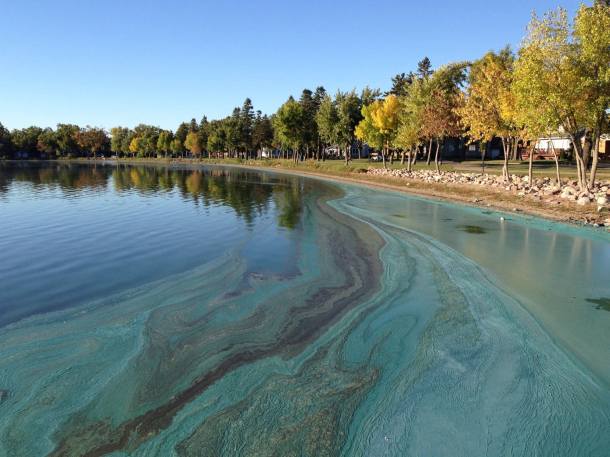
- The Mississippi river crossing near Grand Rapids is designated as an “Outstanding Resource Value Water” and is an important fishery. Because of this designation, there were restrictions on Enbridge construction impacts to the stream channel from April 1 – June 30. Video evidence and the information MPCA released about known frac-outs revealed that Enbridge was conducting HDD construction at this crossing during this restricted date range. A frac out (drilling mud spill) of 6,000 to 9,000 gallons was noted by MPCA to have occurred at this crossing on 6/25/21, during the time when additional temporal restrictions on construction were in place ostensibly to protect this sensitive ecosystem. Date: June 25, 2021. Relevant attachments: Attachment 3-Drone records of frac-outs of drilling mud; Attachment 6 – Water & Drilling Fluid Chemistry – Results & Analysis
- On July 21, MPCA disclosed that drilling mud spilled at the headwaters of the Mississippi River (MP 941.0) contained a proprietary (trade secret) additive called Polyselect POWERPAC-L. Data safety sheets for this chemical listed it as a known “eye, skin, and respiratory” irritant and that it should not be allowed to enter “sewers, waterways, or low areas.” Enbridge knowingly used this additive while drilling near a valuable waterway and failed to follow protocol to fully contain and remove the spilled material from the July 19/20 spill. This harmful additive and the drill mud was present at the surface and 60ft below ground and located within a short distance of the Mississippi River channel. The spill was well within a distance where it could reach the channel via overland flow following a rain event.
- MPCA was unwilling to disclose the chemical makeup of drilling mud even after the mud was spilled to public water ways. On July 23, MPCA Line 3 project manager Melissa Kuskie stated that MPCA evaluated the potential harmful effects of drilling mud additives relative to drinking water standards prior to project permitting. However, Kuskie did not respond to follow-up questions about whether the risks of drilling mud were evaluated by MPCA in relation to the protection of aquatic life (fish, insects, mussels, plants, Manoomin). Date range: June-August, 2021. Relevant attachment: Attachment 6 – Water & Drilling Fluid Chemistry – Results & Analysis
- On July 30, 2021, the Mississippi headwaters crossing (known as MP 941.0) was under active HDD construction by Enbridge. Drone footage taken that day showed that a tributary channel and marshes downhill from the drill site exhibiting an unknown oily sheen/plume on the water surface. No monitoring was conducted by MPCA to identify the origin of this sheen, and no information was released by the agency to the public concerned about whether this sheen could be an impact related to Enbridge construction. Date: July 30, 2021. Relevant attachment: Attachment 3-Drone records of frac-outs of drilling mud.
- Volunteer-led (i.e., citizen science) efforts to analyze water and drilling fluid chemistry at the Mississippi headwaters indicated that the drilling mud contained concentrations of sulfates that could be of concern to the protection of sensitive aquatic ecosystems. In addition, sulfate concentrations in the Mississippi River itself at the frac-out location exceeded the state water quality standard for wild rice waters (10 ppm) on July 28, 2021. Date range: July, 2021. Relevant attachment: Attachment 6 – Water & Drilling Fluid Chemistry – Results & Analysis.
- On July 28 and 29, water samples collected from the Mississippi River headwaters immediately downstream of several known frac outs showed relatively high concentrations of TSS, total phosphorus, oil and grease, total organic carbon, calcium and barium, compared to upstream samples. It is possible that algal growth or some other biochemical event could have contributed to higher concentrations of TSS, total phosphorus, oil and grease and total organic carbon. (Note that the measure of oil and grease used here can detect the presence of contaminants like soap and some petroleum fuels, but also detects things like plant based oils). However, relatively high concentrations of barium are also consistent with a release or spill of drilling mud directly to the river channel. This finding is important because MPCA has never acknowledged contamination of the river channel itself at this location. Additional monitoring by state and/or federal agencies is needed to determine the extent of drilling mud impacts on the Mississippi River and all other sites where fluid was spilled. Relevant attachment: Attachment 6 – Water & Drilling Fluid Chemistry – Results & Analysis.
- Photo evidence and site visits to the frac outs at Mississippi River headwaters revealed that Enbridge failed to follow clean-up protocol for Polyselect POWERPAC-L, which is to “scoop up and remove” it. Instead they plugged holes with sandbags and covered up the drill mud containing this harmful additive. Relevant attachment: Attachment 3-Drone records of frac-outs of drilling mud.
- We question if the frac-outs represent a share of the extra water use and believe that, if there has been a massive loss of boring water and drilling mud, that Class V Injection Well Permits should have been required from the USEPA. If drilling mud and water are being lost during pipe borings, does the water meet the Secondary Drinking Water Standards? Does the operator have USEPA Class V Injection Well Permits for the injected drilling fluids?
- We also question the environmental impact of the biologic and chemical breakdown of the polymer base in the drilling mud. What chemical reactions occur when polymers are broken down into smaller units (monomers)? Are the monomers compatible with our water and water dependent ecosystems?
- We think it is important to address the protection of all of the Municipal Drinking Water Supply Management Areas and private wells where frac-outs have occurred.
False statements and obfuscation by agencies: water appropriations, aquifer breach, and frac outs
Water appropriations
- Randall Doneen (Line 3 project supervisor at MNDNR) falsely stated in a tribal consultation meeting that the additional 4.5 billion gallon water appropriated to Enbridge would require a new permit (rather than a permit amendment). Date: May 27, 2021. Relevant Attachment: Attachment 5-Pleadings for Manooman v MNDNR.
Aquifer breach
- Although MNDNR became aware of the breach of a sensitive artesian aquifer by Enbridge in June 2021, the public was not made aware until September 16, 2021. This, despite (i) widespread public and scientific concern about the project’s impacts on groundwater, and (ii) direct questioning from independent scientists about whether Enbridge might have committed serious errors in their understanding of groundwater in the area. Date: June-September, 2021. Relevant attachment: Attachment 4 Ruptured Aquifer Summary and Detailed Report.
Frac outs/Drilling Fluid Spills
- On July 21, the day after water protectors witnessed first-hand a frac out occurring in a wetland in the floodplain of the Mississippi River headwaters, MPCA tweeted that “A lot of misinformation is being shared on social about potential frac-outs, especially re: Shell River & Mississippi Headwaters. 9 construction sites have had inadvertent releases of drilling fluid, but Willow River is the only crossing where drilling fluid entered the waterway. All others occurred near drilling locations.” This was an attack on the credibility of Tribal representatives, Water Protectors and other concerned members who were witnessing frac-outs in real time on the ground and raising the alarm. The MPCA then subsequently tweeted statements inaccurately characterizing the proximity of frac-out sites to waterways and how many frac-out sites resulted in drilling material entering a waterway. Based on the documented occurrence of a frac out directly in a wetland immediately adjacent to the Mississippi river on July 20, 2021 (and not near the drilling entry/exit point), this statement by MPCA was blatantly false and misleading, and sought to dismiss the careful documentation by water protectors on the ground.These tweets revealed the bias MPCA has toward Enbridge and against the public in their willingness to accept Enbridge’s characterization of frac-outs and deem evidence presented by Water Protectors as “misinformation.” These tweets were removed by MPCA by July 23. To our knowledge, staff from MPCA have never been to a frac-out site to monitor and assess past or current impacts from drilling mud spills. Date: July 21, 2021. Relevant attachment: Attachment 3-Drone records of frac-outs of drilling mud; Attachment 6: Water and Drilling Fluid Chemistry: Results & Analysis.
- MPCA staff repeatedly told concerned members of the public that the frac outs at Mississippi River crossing (MP 941.0) are “outside the river nearer to the entry or exit point (than the river itself is).” Drone photos clearly show multiple frac outs at this location in the river floodplain, in close proximity to river channels and in direct hydrologic connection to surface water. Date: July 20-21. Relevant attachments: Attachment 3- Drone records of frac-outs, and Attachment 8- Email communications.
- From June until August, MPCA refused to release complete or accurate information about frac-outs, and still have not disclosed whether they are conducting any sampling to monitor for impacts of drilling mud to surrounding water bodies, etc. On August 9, MPCA released information about 28 frac outs only after direct pressure from 32 state legislators and many members of the public. Frac-outs have an as-yet undefined risk to aquifers and surface water resources. Date: May-Present, 2021. Relevant attachments: Attachment 6: Water and Drilling Fluid Chemistry: Results & Analysis.
Violations that weren’t reported
Aquifer breach
- The illegal breach of an aquifer on January 21, 2021 by Enbridge during Line 3 construction resulted in a cascade of compounding illegal activities by Enbridge and failures by agencies to address the problem or notify the public. Date Range: January-September, 2021. Relevant attachment: Attachment 4 Ruptured Aquifer Summary and Detailed Report.
- On January 21, 2021, Enbridge Project Managers and contractors decided that the permitted design for the bore pit at the Clearbrook Terminal was not deep enough to allow boring beneath two existing pipelines (Line 3 had to make a “hot crossing” beneath two high-pressure pipelines). Enbridge made a field-decision in violation of their approved permit to make a 16 to 18-foot bore pit in a 50-foot-long trench box. There was no notification of Level 2 modifications or need for amended permits. Date: January 21, 2021. Relevant attachment: Attachment 4-Ruptured Aquifer Summary and Detailed Report.
- The 18-foot-deep trench immediately ruptured the artesian aquifer as it approached the east end of the trench near the hot crossings. The pressurized aquifer ruptured near the existing pipelines, and uncontrollable water rushed to the surface. Rather than reporting the aquifer breach, the Independent Environmental Monitors (IEM’s) overlooked the design changes and permit violations. On January 26, the Monitors did not report any changed conditions other than “unmanageable dewatering conditions” and the need for SWPPP to direct new flow across the roadway. On February 2, the IEM’s again obfuscate the truth by saying that borehole excavation or entry pit encountered simply “excessive GW [groundwater] infiltration.” Enbridge’s failure to report the aquifer breach violated their water appropriation permits, water discharge permits, and wetland permits. Date Range: January 21-February 2, 2021. Relevant attachment: Attachment 4-Ruptured Aquifer Summary and Detailed Report.
- When the water came welling up as a “large boiling sand spring” it created quicksand in the pipeline trench and the Contractor abandoned the deep bore pit effort in fear of losing their equipment. But once they stopped dewatering and pulled out the sheet pile wall, which Enbridge contractors had installed to control the artesian flow, a new aquifer rupture occurred 60 feet west of the original rupture—magnifying the difficulty of stopping the uncontrolled flow. Enbridge did not report this additional aquifer rupture until July 8, 2021. January 21-July, 2021. Relevant attachment: Attachment 4-Ruptured Aquifer Summary and Detailed Report.
- The next six months left a legacy of inspectors failing to report alarming water and quicksand hazards. The uncontrolled groundwater flow and the pipeline springs have continued unabated for almost nine months. The loss of pure groundwater has now totaled 24.2 million gallons (Jan 21 – Sept 5) at a rate of up to 106,608 gallons a day, which is enough to sustain multiple springs and many acres of groundwater-dependent wetlands in extreme drought and depleting the aquifer. Uncontrolled flow created the risk of bank sloughing, road overtopping, and water quality concerns from the release of turbid water (which Enbridge admitted in July did reach a nearby stream). Moreover, Enbridge continued their pipeline installation during this time period and completed construction. Continuing the work compounds the violations. Date: January-present, 2021. Relevant attachment: Attachment 4-Ruptured Aquifer Summary and Detailed Report.
Other permit violations
- An unknown number of serious permit violations occurred during Line 3 construction which are regulated by the MPCA and the US Army Corp of Engineers, including discharge of silt and mud into streams and wetlands which violates Construction Site Stormwater Permits and wetland protections. MPCA has refused to disclose any information about these violations, claiming they are “under investigation”. Date range: January-present, 2021. Relevant attachment: Attachment 4-Ruptured Aquifer Summary and Detailed Report.
Other Ongoing Problems
- The PUC required Enbridge to have a Line 3 “Decommissioning Trust Fund” in place as a permit condition. Enbridge has not showed any sign of doing so as of October 2021.
- Enbridge is unlikely to have comprehensive insurance for Line 3 in the long term, as required by the PUC permit. Date: as of October 2021.


Leave a comment